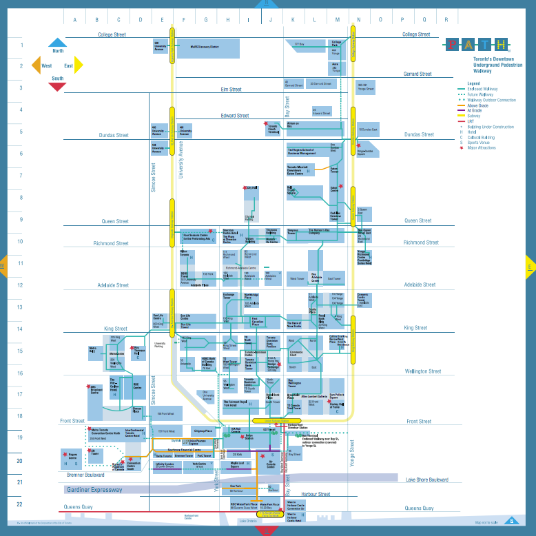
토론토에는 거대한 지하연결상가들이 있다. 겨울이 길고 혹한의 추위가 있는 토론토의 자연환경 때문에, 오래 전 부터 다운타운의 비즈니스 지역에 서로 지하로 통로를 만들어 연결해 왔는데 이것을 "PATH" 라고 부른다.
아래에 PATH 지도를 보여주는데, 날씨가 추울 때에는 이 지하거리들을 둘러보는 것도 토론토의 좋은 관광거리가 된다.
PATH 는 총 길이 30킬로미터, 연면적 371,600 square metres (4,000,000 sq ft)의 세계최대규모의 지하상가로 기네스북에 등재되었다.
PATH 는 북쪽 입구가 the Toronto Coach Terminal(Dundas St 와 Bay St 사거리 인근)에서 시작하며, 남쪽 입구는 Waterpark Place(Queens Quay 에 위치)에 있으며, PATH 지하통로는 주로 Yonge St 와 Bay St 를 따라 남북으로 연결되어 있다.
아래의 지도를 클릭해도 토론토시청에서 제공하는 PATH map 원본을 다운로드할 수 있다.
Visiting a client? Shopping for a gift? Taking in a movie? Catching the subway?

PATH is downtown Toronto's (mostly) underground walkway linking 30 kilometres of shopping, services and entertainment. Follow PATH and you'll reach your downtown destination easily in weatherproof comfort.

PATH provides an important contribution to the economic viability of the city's downtown core. The system facilitates pedestrian linkages to public transit, accommodating more than 200,000 business-day commuters, and thousands of additional tourists and residents on route to sports and cultural events. Its underground location provides pedestrians with a safe haven from the winter cold and snow, and the summer heat.

PATH Facts

The approximate 1,200 shops and services, such as photocopy shops and shoe repairs, found in PATH, employ about 5,000 people. Once a year, businesses in PATH host the world's largest underground sidewalk sale.
More than 50 buildings/office towers are connected through PATH. Twenty parking garages, six subway stations, two major department stores, eight major hotels, and a railway terminal are also accessible through PATH. It also provides links to some of Toronto's major tourist and entertainment attractions such as: the Hockey Hall of Fame, Roy Thomson Hall, The Air Canada Centre, Rogers Centre, and the CN Tower. City Hall and Metro Hall are also connected through PATH.
There are more than 125 grade level access points and 60 decision points where a pedestrian has to decide between turning left or right, or continuing straight on. The average size of a connecting link is 20 metres (66 feet) long by 6 metres (20 feet) wide.
The building furthest north on the PATH network is College Park at College and Yonge Streets. The building furthest south that can be accessed through PATH is the RBC WaterPark Place building which is just across the street from the Toronto Island ferry terminal and the Westin Harbour Castle hotel. PATH does not follow the grid patterns of the streets above.
Each letter in PATH is a different colour, each representing a direction. The P is red and represents south. The orange A directs pedestrians to the west, while the blue T directs them to the north. The H is yellow and points to the east.
Signage includes a symbol for people with disabilities whenever there is a flight of stairs ahead.

PATH History

The first underground path in Toronto originated in 1900 when the T Eaton Co. joined its main store at 178 Yonge St. and its bargain annex by tunnels. By 1917 there were five tunnels in the downtown core. With the opening of Union Station in 1927, an underground tunnel was built to connect it to the Royal York Hotel (now known as the Fairmont Royal York). The real growth of PATH began in the 1970s when a tunnel was built to connect the Richmond-Adelaide and Sheraton Centres.
In 1987, City Council adopted the recommendation that the City become the co-ordinating agency of PATH and pay for the system-wide costs of designing a signage program.
In 1988, design firms Gottschalk, Ash International, and Keith Muller Ltd. were retained in by the City of Toronto to apply the design concept for PATH.
PATH's name and logo are registered to the City of Toronto. The City co-ordinates and facilitates the directional signage, maps and identity markers throughout the system.
Each segment of the walkway system is owned and controlled by the owner of the property through which it runs. There are about 35 corporations involved.
In the early 1990s, signage for PATH was developed to provide pedestrians with better ease of use and functionality. The signage enhances PATH's visibility and identity, ultimately increasing its use, attracting more people to downtown Toronto, and drawing more businesses there.


